 Catalogue PIGMA
MIO UMR 7294 CNRS
Type of resources
Available actions
Topics
Keywords
Contact for the resource
Provided by
Formats
Representation types
Update frequencies
status
Scale
-
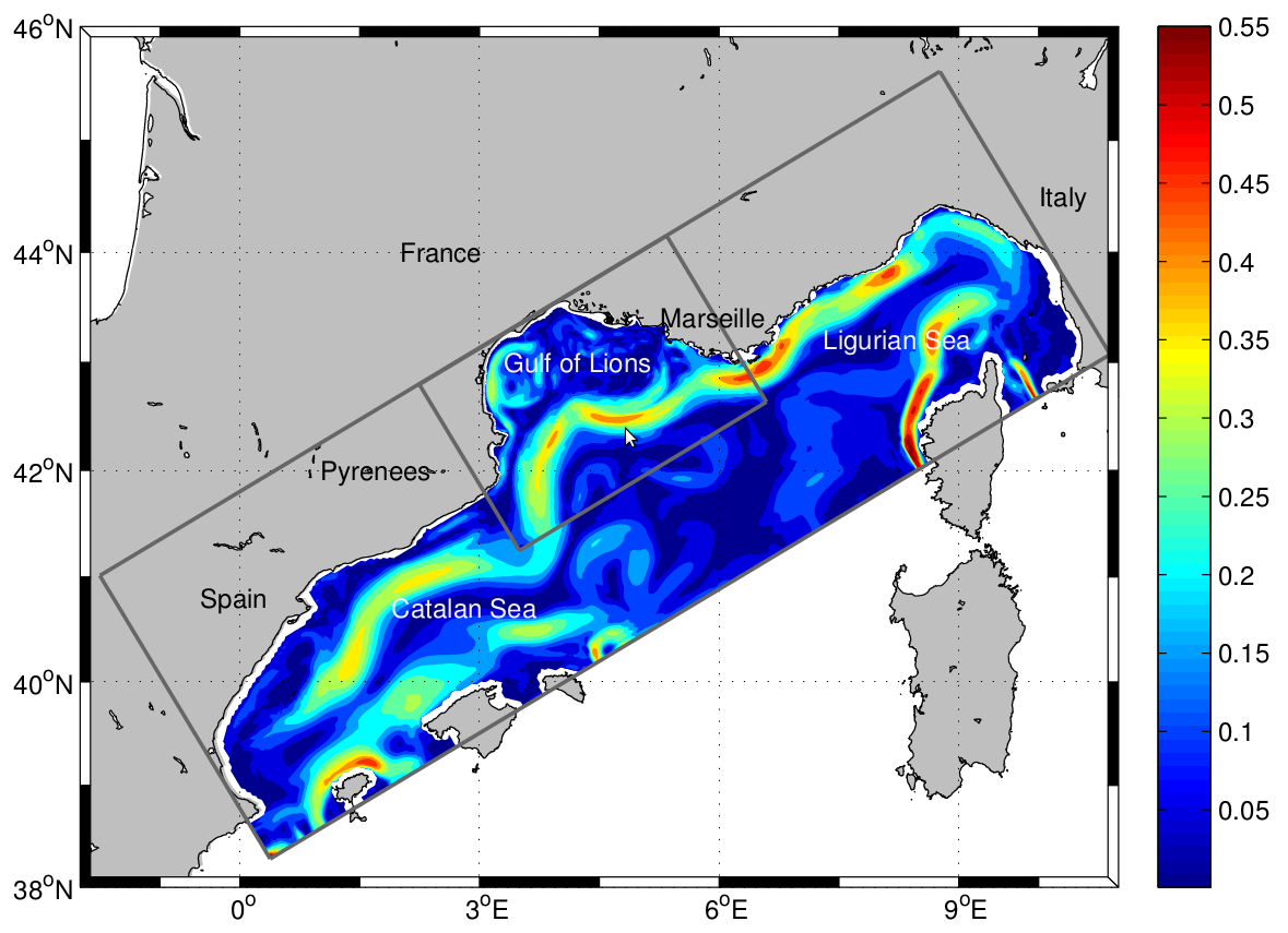
The LAgrangian Transport EXperiment (LATEX) project (2008-2011) is designed to study the mechanisms of formation of anticyclonic eddies and their influence on cross-shelf exchanges in the western part of the GoL. The dynamics of mesoscale eddies is particularly important in this part of the GoL since it represents a key region for regulating the outflow from the continental shelf. The eddy dynamics is investigated using Symphonie, a 3-dimensional, primitive equation model, with a free sea surface, hybrid sigma coordinates, based on Boussinesq and hydrostatic approximations [Marsaleix et al., 2006, 2008]. We use the upwind-type advection-diffusion scheme adapted by Hu et al. [2009] to improve the ability of the model to reproduce coastal mesoscale eddies in the western part of the GoL. In the present study, the model is implemented over the whole GoL with an horizontal resolution of 1 km × 1 km (Figure 1). The vertical discretization consists of 40-hybrid vertical levels. The vertical resolution varies from 1 m in the upper ocean to 40 m near the bottom. "For a complete review of the LATEX projet, see : - Petrenko, A., A., Doglioli, A.M., Nencioli, F., Kersalé, M., Hu, Z., d'Ovidio, F. (2017). A review of the LATEX project: mesoscale to submesoscale processes in a coastal environment. Ocean Dynam., 67:513 - doi: 10.1007/s10236-017-1040-9 - https://doi.org/10.1007/s10236-017-1040-9 ----- Le projet LAgrangian Transport EXperiment (LATEX) (2008-2011) est conçu pour étudier les mécanismes de formation des tourbillons anticycloniques et leur influence sur les échanges entre plateaux dans la partie occidentale du GdL. La dynamique des tourbillons à méso-échelle est particulièrement importante dans cette partie du GdL, car elle représente une région clé pour la régulation du flux sortant du plateau continental. La dynamique des tourbillons est étudiée à l'aide de Symphonie, un modèle d'équation primitive tridimensionnel, avec une surface de mer libre, des coordonnées sigma hybrides, basé sur Boussinesq et des approximations hydrostatiques [Marsaleix et al., 2006, 2008]. Nous utilisons le schéma d'advection-diffusion de type vent debout adapté par Hu et al [2009] pour améliorer la capacité du modèle à reproduire les tourbillons côtiers à méso-échelle dans la partie occidentale du GdL. Dans la présente étude, le modèle est mis en œuvre sur l'ensemble du GdL avec une résolution horizontale de 1 km × 1 km (Figure 1). La discrétisation verticale est constituée de 40 niveaux verticaux hybrides. La résolution verticale varie de 1 m dans la partie supérieure de l'océan à 40 m près du fond. Pour plus d'information sur le projet LATEX : - Petrenko, A., A., Doglioli, A.M., Nencioli, F., Kersalé, M., Hu, Z., d'Ovidio, F. (2017). A review of the LATEX project: mesoscale to submesoscale processes in a coastal environment. Ocean Dynam., 67:513 - doi:10.1007/s10236-017-1040-9 - https://doi.org/10.1007/s10236-017-1040-9
-
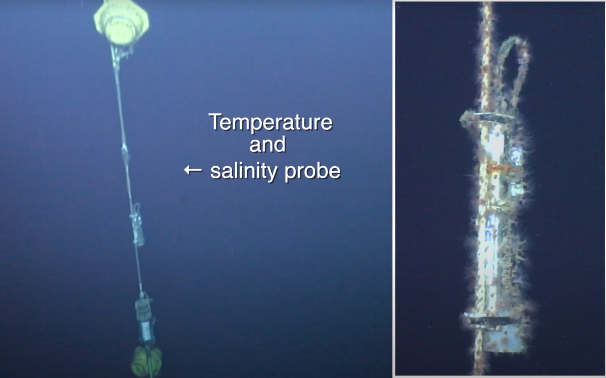
ABSTRACT : Time series of the monthly means of potential temperature, salinity and potential density recorded on the HydroChanges consecutive moorings in the Gulf of Lion (41° 59.0' N 04° 55' E) few meters above the bottom (~2320m), between 2006 and 2011. N.B.: data from 2003 to 2006 exist but moorings are yet to be recovered. Observing strategy Mooring with 1 Seacat SBE37 and usually one currentmeter. Seacat SBE37 fitted with pump and pressure sensor for accurate computation of the salinity, and mostly sent to recalibration at SeaBird after their deployment. REFERENCE : http://www.ciesm.org/marine/programs/hydrochanges.htm Schroeder K.et al., 2013. Long-term monitoring of the hydrological variability in the Mediterranean Sea: the HYDROCHANGES network. Ocean Sci., 9, 301-324, doi:10.5194/os-9-301-2013 INSTRUMENT INFORMATION : Instrument type CTD > Conductivity, Temperature, Depth Manufacturer Sea-Bird Electronics, Inc. - http://www.seabird.com Model SBE 37 Instrument features / Calibration pressure sensor, pump, recalibration Observation frequency monthly mean Longitude (°) 4.9167 Latitude (°) 41.983
-
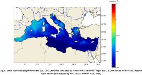
"Towards an integrated prediction of Land & Sea Responses to global change in the Mediterranean Basin" The LaSeR-Med project aims at investigating the effects of climate change and of mediterranean population growth on some major indicators of the Mediterranean Sea (primary production, carbon export, zooplankton biomass available for small pelagic fishes, pH, dissolved oxygen) using and integrated model encompassing a socio-economic model, a continental model of agro-ecosystems, and a physical ocean-atmosphere model coupled to a biogeochemical model of the ocean. Last, a model for the widespread species of jellyfish Pelagia Noctiluca (Berline et al., 2013) uses biogeochemical outputs as food forcing for the jellyfish. In this project, our aim was first to investigate the large-scale and long-term impacts of variations in river inputs on the biogeochemistry of the Mediterranean Sea over the last decades (see Pages et al., 2020a). In the second phase, a climate scenario (RCP8.5) alone (Pages et al., 2020b) or combined with a “land-use” scenario derived to ensure the same level of food availability as today in 2050 have been run to investigate its effect on these indicators and to analyze the observed changes on the structure and the functioning of planktonic food web. This interdisciplinary project provided the framework for joint discussions on each of the sub-models that constitute the integrated model, namely the socio-economic model (Ami et al., in prep., Mardesic et al., in prep.) created ex nihilo by researchers from AMSE, INRA and GREQAM, the continental agro-ecosystem model LPJmL (Bondeau et al., 2007) worked on at IMBE so as to include the nitrogen and phosphorous cycles in the frame of the present project, and the ocean biogeochemical model Eco3M-Med developed at MIO (Baklouti et al., 2006; Alekseenko et al. 2014, Guyennon et al., 2015; Pagès et al., 2020a), forced by ocean physics, either using the ocean model NEMO-Med12 forced by atmosphere at IPSL (simulation NM12-FREE run with the NEMO-MED12 model and used for our hindcast simulation, see below) or a coupled ocean-atmosphere model at CNRM (physical forcing provided by CNRM-RCSM4, see below). Details on the CNRM-RCSM4 model The CNRM-RCSM4 simulates the main components of the Mediterranean regional climate system and their interactions. It includes four different components: (i) The atmospheric regional model ALADIN-Climate (Radu et al., 2008; Colin et al., 2010; Herrmann et al., 2011) characterized by a 50 km horizontal resolution, 31 vertical levels, and a time step of 1800 s, (ii) the ISBA (Interaction between Soil Biosphere and Atmosphere) land-surface model (Noilhan and Mahfouf, 1996) at a 50 km horizontal resolution, (iii) the TRIP (Total Runoff Integrating Pathways) river routing model (Oki and Sud, 1998), used to convert the runoff simulated by ISBA into rivers (Decharme et al., 2010; Szczypta et al., 2012; Voldoire et al., 2013), and (iv) the Ocean general circulation model NEMO (Nucleus for European Modeling of the Ocean, Madec and NEMO-Team, 2016) in its NEMO-MED8 regional configuration (Beuvier et al., 2010). NEMO-MED8 is characterized by a horizontal resolution of 1/8° (grid cells size from 6 to 12 km), a vertical resolution of 43 vertical levels (cell height ranging from 6 to 200 m), and a time step of 1200 s. More details about the CNRM-RCSM4 model can be found in Sevault et al. (2014). Keywords: - Mediterranean Sea, river inputs, chlorophyll, nutrients, phytoplankton, bacteria, zooplankton, dissolved and particulate organic detrital matter Citation: Pagès, R., Baklouti, M., Barrier, N., Richon, C., Dutay, J.-C., and Moutin, T. (2020a). Changes in rivers inputs during the last decades significantly impacted the biogeochemistry of the eastern Mediterranean basin: a modelling study. Prog. Oceanogr. 181:102242. doi:10.1016/j.pocean.2019.102242 Pagès, R., Baklouti, M., Barrier, N., Ayache, M., Sevault, F., Somot, S. and Moutin, T. (2020b). Projected Effects of Climate-Induced Changes in Hydrodynamics on the Biogeochemistry of the Mediterranean Sea Under the RCP 8.5 Regional Climate Scenario. Front. Mar. Sci. 7:563615. doi:10.3389/fmars.2020.563615 Ayache, M., Bondeau, A., Pagès, R., Barrier, N., Ostberg, S. and Baklouti, M. (2020). LPJmL-Med – Modelling the dynamics of the land-sea nutrient transfer over the Mediterranean region–version 1: Model description and evaluation. Geoscientific Model Development Discussions, Copernicus Publ.
-
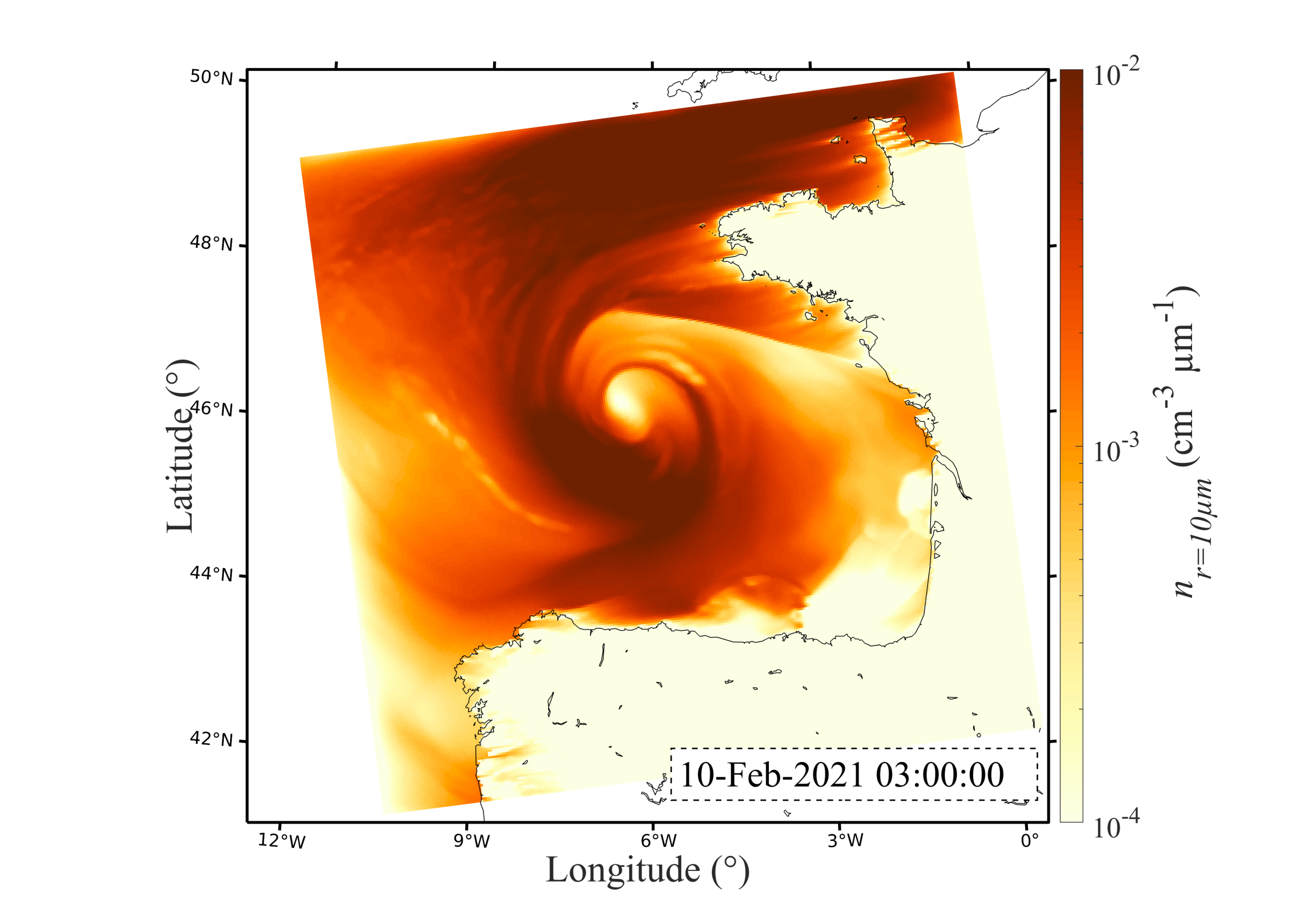
In the context of the SUMOS research cruise (2021) where sea spray concentrations were measured in February and March 2021 in the Bay of Biscay, the present dataset gathers numerical simulations of sea spray transport achieved with the MesoNH model. This dataset gathers MesoNH model outputs every hour over a 600x600km grid (300x300 cells) centered over the Bay of Biscay. The model was forced using the ECMWF model every three hours. Three sea spray generation functions are used to parameterize the sea spray generation flux: OVA14 (Ovadnevaite et al. 2014), B21A and B21B (Bruch et al. 2021). Modeled number concentrations are extracted at 2 µm radius for OVA14, and 2, 5, 10 and 20 µm for both B21A and B21B. The database presents these concentrations along a horizontal cross-section across the entire domain at 15 meters above mean sea level. This data is presented as 3D matrices structure as follows : Time x Longitude x Latitude. The database also provides the number concentration distribution as a function of particle radius (n(r)) at the location nearest to the Atalante vessel. Both horizontal wind speed components U and V are provided over the entire grid, as well as the horizontal wind speed sqrt(U²+V²) at the location nearest to the Atalante vessel. Units : Wind speed (m/s), number concentrations (#/cm3), Longitude and Latitude (Degrees). More information about the dataset can be found in the publication by (Bruch et al. 2023 – JGR – Atmosphere).
-
"Towards an integrated prediction of Land & Sea Responses to global change in the Mediterranean Basin" The LaSeR-Med project aims at investigating the effects of climate change and of mediterranean population growth on some major indicators of the Mediterranean Sea (primary production, carbon export, zooplankton biomass available for small pelagic fishes, pH, dissolved oxygen) using and integrated model encompassing a socio-economic model, a continental model of agro-ecosystems, and a physical ocean-atmosphere model coupled to a biogeochemical model of the ocean. Last, a model for the widespread species of jellyfish Pelagia Noctiluca (Berline et al., 2013) uses biogeochemical outputs as food forcing for the jellyfish. In this project, our first aim was to investigate the large-scale and long-term impacts of variations in river inputs on the biogeochemistry of the Mediterranean Sea over the last decades (see Pages et al., 2020a). This interdisciplinary project provided the framework for joint discussions on each of the sub-models that constitute the integrated model, namely the socio-economic model (Ami et al., in prep., Mardesic et al., in prep.) created ex nihilo by researchers from AMSE, INRA and GREQAM, the continental agro-ecosystem model LPJmL (Bondeau et al., 2007) worked on at IMBE so as to include the nitrogen and phosphorous cycles in the frame of the present project, and the ocean biogeochemical model Eco3M-Med developed at MIO (Baklouti et al., 2006; Alekseenko et al. 2014, Guyennon et al., 2015; Pagès et al., 2020a), forced by ocean physics, either using the ocean model NEMO-Med12 forced by atmosphere at IPSL (simulation NM12-FREE run with the NEMO-MED12 model and used for our hindcast simulation, see below) or a coupled ocean-atmosphere model at CNRM (physical forcing provided by CNRM-RCSM4, see below). Details on simulation NM12-free: The historical simulation used in this work is referred to as the NM12-FREE (no reanalysis no data assimilation) which started in October 1979 and ended in June 2013 (Hamon et al., 2016). It has been run with the general circulation model NEMO in its regional configuration NEMO-MED12 based on a horizontal resolution of 1/12 de degree (6.5 to 8 km cells) and a 75-level vertical resolution (of 1 m width at the surface to 135 m at the seabed). For this simulation, runoff and river inputs in the NM12 domain came from the inter-annual data of Ludwig et al. (2009) and the atmospheric forcing was based on the dynamical downscaling of the ERA-INTERIM reanalysis, i.e. ALDERA which has a 12 km spatial resolution and a 3 h temporal resolution. More details on the NM12-FREE simulation are given in Hamon et al. (2016). Keywords: - Mediterranean Sea, river inputs, chlorophyll, nutrients, phytoplankton, bacteria, zooplankton, dissolved and particulate organic detrital matter Citation: Pagès, R., Baklouti, M., Barrier, N., Richon, C., Dutay, J.-C., and Moutin, T. (2020a). Changes in rivers inputs during the last decades significantly impacted the biogeochemistry of the eastern Mediterranean basin: a modelling study. Prog. Oceanogr. 181:102242. doi:10.1016/j.pocean.2019.102242 Ayache, M., Bondeau, A., Pagès, R., Barrier, N., Ostberg, S. and Baklouti, M. (2020). LPJmL-Med – Modelling the dynamics of the land-sea nutrient transfer over the Mediterranean region–version 1: Model description and evaluation. Geoscientific Model Development Discussions, Copernicus Publ.
-
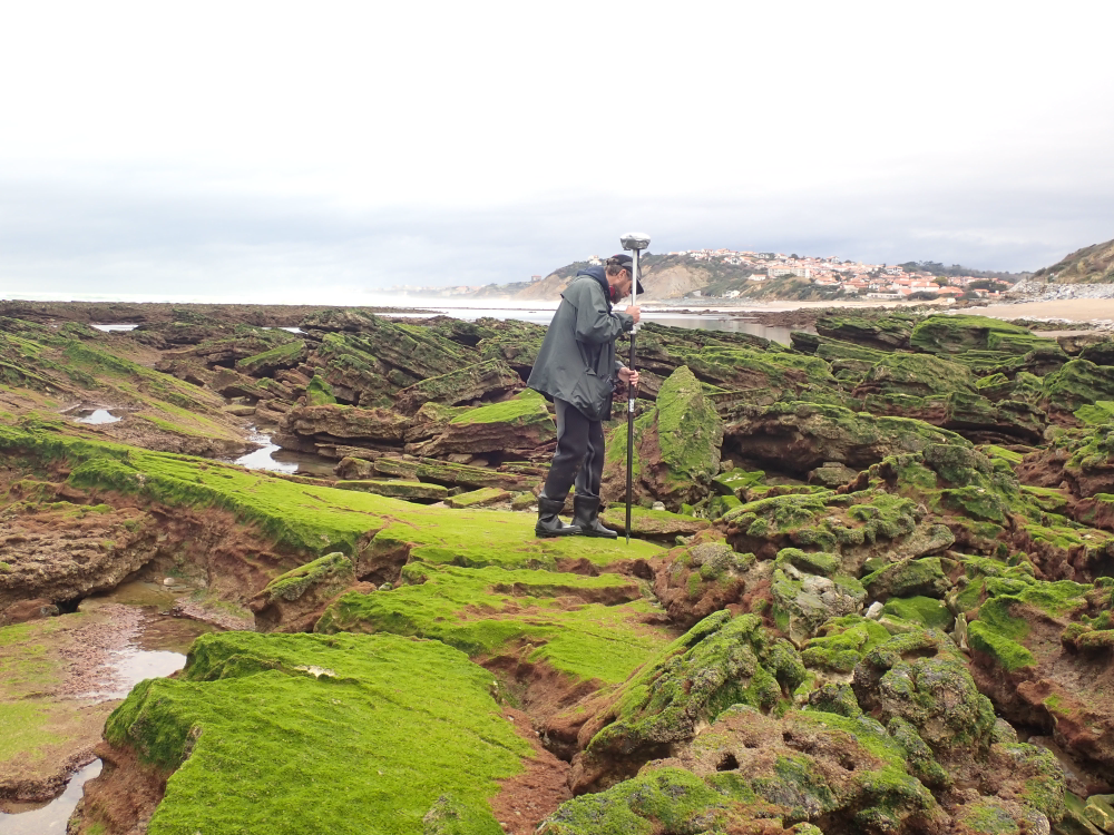
The present dataset is based on a nine site study of fine seabed topography in intertidal zones. Four coral sites (Maupiti A, B and C and Niau islands) and five rocky sites (Ars en Ré, Socoa, Parlementia A and B and Banneg island) have been explored. The data has been gathered using on-foot GNSS RTK for all sites (Trimble R8/R8S and Leica sytems) except Banneg island, where aerial Lidar data from Litto3D program has been used. The horizontal resolution varies between 3.8 and 12cm allowing to describe a wide range of spatial scales (generally over 3 spectral decades). The data has been processed to explore the statistical and spectral metrics which can be used to characterize the architectural complexity of seabeds. Owners: - Topographic survey on Ars-en-Ré : profile X, Z in meter along a transec was operated on 10-15 Jan 2021 with On-foot Trimble R8/R8S GNSS RTK by Shom, Gladys and Univ. de Montpellier - Topographic survey on Maupiti Hoe: profile X, Z in meter along a transec was operated on 5-10 July 2018 with on-foot Trimble R8/R8S GNSS RTK by GLADYS and Université de Montpellier - Topographic survey on Niau : profile X, Z in meter along a transec operated on 10 Nov. 2021 with On-foot Trimble R8/R8S GNSS RTK - by CEREGE and MIO (OSU Pytheas) - Topographic survey on Parlementia A, and B : profile X, Z in meter along a transec was operated on 22 Fev 2023 with on-foot Leica GNSS RTK by SIAME, UPPA - Topographic survey on Socoa : profile X, Z in meter along a transec was operated on 21 Fev 2023 with on-foot Leica GNSS RTK by SIAME, UPPA and Shom - Topographic survey in high resolution of Banneg island (X, Y, Z) is made by aerial lidar litto3D on spring 2012/2013 by Shom and IGN